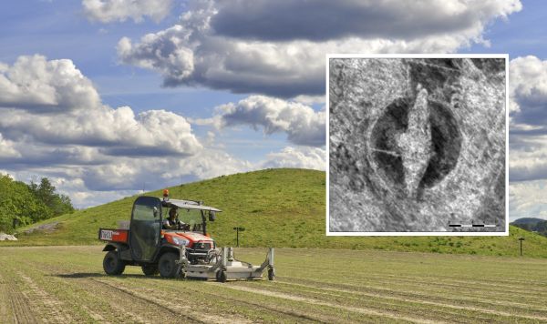
Archaeologists armed with a motorized high
resolution georadar have found a Viking ship and a large number
of burial mounds and longhouses in Østfold County in Norway. The
discoveries were made by archaeologists from the Norwegian
Institute for Cultural Heritage Research (NIKU) with technology
developed by the Ludwig Boltzmann Institute for Archaeological
Prospection and Virtual Archaeology (LBI ArchPro).
The Viking ship find is just below the topsoil, at a depth of
approximately 50 cm initially buried in a burial mound. The
digital data visualizations reveal a large and well-defined 20 m
long ship-shaped structure. The data indicate that the lower
part of the ship is still preserved. Further non-invasive
investigations are planned to digitally map the unique find and
the wider landscape.
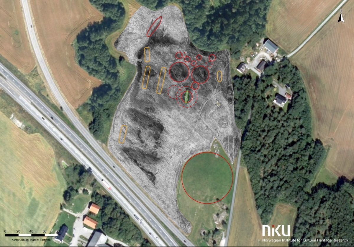
The sensational find is located at Viksletta right next to the
monumental Jelle mound in Østfold County, Norway. The team has
discovered the traces of at least eight so far unknown burial
mounds destroyed by ploughing. But with the help of georadar,
the remnants and enclosing ditches of these massive monuments
can still be mapped in detail. One of the former mounds clearly
shows the remains of a Viking ship initially buried in the mound.
There are clear indications that the ship's keel and floor
timbers are preserved in the grave. Based on other Viking ship
finds the archaeologists worked out a first hypothetical
reconstruction of the ship.
- We are certain that there is a ship there, but how much is
preserved is hard to say before further investigation”, says
Morten Hanisch, county conservator in Østfold.
- This find is incredibly exciting as we only know three
well-preserved Viking ship finds in Norway excavated long time
ago. This new ship will certainly be of great historical
significance as it can be investigated with all modern means of
archaeology", says Dr. Knut Paasche, Head of the Department of
Digital Archaeology at NIKU, and an expert on Viking ships.
Beside the monumental burial mounds, the georadar data revealed
5 longhouses - some of them remarkably large – a situation
comparable to the site Borre in Vestfold County, on the opposite
side of the Oslofjord.
“The ship burial does not exist in isolation, but forms part of
a cemetery which is clearly designed to display power and
influence”, says archaeologist Lars Gustavsen, project leader
from NIKU.
The archaeologists from NIKU are now proposing a research
project to further investigate the Gjellestad ship, the site and
the surrounding landscape with non-invasive methods before any
excavations. It is planned to use additional non-invasive
geophysical methods which will provide more insight into the
ground and provide additional facts on the ship without having
to dig it up and expose it to the elements. Nevertheless, the
professionals do not rule out that it may be necessary to make
an excavation in the long term.
The georadar investigations at the Jell Mound were carried out
by NIKU in close cooperation with the county council of Østfold.
Fieldwork was conducted by Erich Nau and Lars Gustavsen. The
methodology and software used in the surveys were developed by
the LBI ArchPro.